

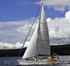
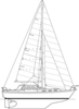
I fancy sailing up Loch Etive again this year but I'm unclear if Dogdays will fit under Connel Bridge (charted clearance 14m) and Bonawe electric cable (charted 13m). The air draft is 15.3m.
The charted clearance is above Highest Astronomical Tide. I can readily find MHWS for Oban (4.0m), Connel (3.7m) and Bonawe (2.0m) but I don't think that's the figure I need.
Can anyone point to a source of HAT?
I know the wires at Bonawe are much higher at the north side than south; is the clearance figure for the lowest part (where the water is quite shallow)?
I took a long length of rope onto the bridge this afternoon near slack water (2h after LW Oban; it's a Mean Spring Tide today). According to Absolute Tides, the height at 16:15 was 1.3m at Oban and 1.2m at Connel; my paper calculation using Reeds graph got 1.5m at Oban. So in theory, using MHWS instead of HAT, the clearance should be 14+4-1.3 =16.7 according to Oban or 14+3.7-1.2 =16.5m according to Connel. The measurement (surprisingly challenging to get the bottom of the bridge) was 19.0m.
Which suggests the hydrographer is very pessimistic or HAT is 2.5m higher than MHWS or I did something wrong in measuring or calculating.
Any informed observations?
(I don't plan to repeat the rope trick at Bonawe!)
Regards,
Derek
edit I just found that HAT is listed at the bottom of each page of tide tables in Reeds. So I have the data fro Oban: HAT is 4.5m so the Oban calculation now gives 17.2m clearance at 16:15 today but I can't get the information for Connel (I can guess it's not much different from Oban) or Bonawe which is much more challenging.
Back to basics - Clearance under bridges
-
Orla
- Master Mariner
- Posts: 196
- Joined: Sun Sep 24, 2006 5:08 pm
- Boat Type: Lafitte 44
- Location: West Coast Scotland
- Contact:
Re: Back to basics - Clearance under bridges
All sounds way over my head 
I don't thing I would try this:-
[photobucket] [/photobucket]
I don't thing I would try this:-
[photobucket]
 [/photobucket]
http://www.yachtorla.com" onclick="window.open(this.href);return false;
-
Telo
- Admiral of the Red
- Posts: 2505
- Joined: Wed Jan 05, 2005 9:27 pm
- Boat Type: Vancouver 34 Pilot
- Location: Bampotterie-sur-mer
- Contact:
Re: Back to basics - Clearance under bridges
Things come full circle sometimes - it was your comments on a much earlier thread that prompted us to sail up Loch Etive a few years ago - viewtopic.php?f=2&t=4939 
Re Bonawe, vertical clearance heights are all based on HAT (says BA2388), ie 13m at the lowest part of the span. I must admit, we were very nervous about the HT cable at Bonawe, but took your advice and went through at about 20m off the North bank.
Later on, I dug out the photograph of the HT cables and superimposed red dots on the lowest of the cables - there does seem to be a lot of clearance on the North side.
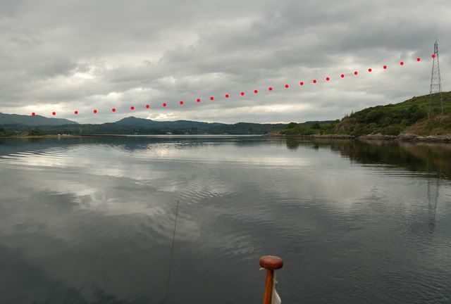
Don't know if it's any comfort, but I'm sure we'd have heard if someone had come to grief on the cable. Mr Google has had no reports.
Re Bonawe, vertical clearance heights are all based on HAT (says BA2388), ie 13m at the lowest part of the span. I must admit, we were very nervous about the HT cable at Bonawe, but took your advice and went through at about 20m off the North bank.
Later on, I dug out the photograph of the HT cables and superimposed red dots on the lowest of the cables - there does seem to be a lot of clearance on the North side.
Don't know if it's any comfort, but I'm sure we'd have heard if someone had come to grief on the cable. Mr Google has had no reports.
Re: Back to basics - Clearance under bridges
Perhaps I'll entice Jane onto the end of the boom and all my worries will be over?Orla wrote:All sounds way over my head
I don't thing I would try this:-
[photobucket]
-
Telo
- Admiral of the Red
- Posts: 2505
- Joined: Wed Jan 05, 2005 9:27 pm
- Boat Type: Vancouver 34 Pilot
- Location: Bampotterie-sur-mer
- Contact:
Re: Back to basics - Clearance under bridges
Is that a black eye you've got, Derek?
Re: Back to basics - Clearance under bridges
Not yet.Telo wrote:Is that a black eye you've got, Derek?
Re: Back to basics - Clearance under bridges
Sorry to revive an ancient topic, I am interested in this bridge  . HAT can indeed be a meter higher than MHWS.
Interestingly, the US NGA publishes a 15m in their most recent Publication Nr. 141 (newest version here: https://msi.nga.mil/NGAPortal/MSI.porta ... bCode=0010 ), no idea though if their reference is HAT or MHWS.
Interestingly, the US NGA publishes a 15m in their most recent Publication Nr. 141 (newest version here: https://msi.nga.mil/NGAPortal/MSI.porta ... bCode=0010 ), no idea though if their reference is HAT or MHWS.
-
pagoda
- Master Mariner
- Posts: 225
- Joined: Sat Jun 18, 2011 1:17 pm
- Boat Type: Jeanneau 42iPerformance
- Location: Near Montrose, boat on the Firth of Clyde
Re: Back to basics - Clearance under bridges
Bridges I can almost cope with - We went under Fehmarn Bridge on the way back from Kiel to Scotland. Nominally 22m . Our VHF is about 20.5m . There were tide gauges on the bridge supports but it was still a bit scary.
http://www.23hq.com/pagoda54/photo/54533972/original
underneath: http://www.23hq.com/pagoda54/photo/54533909/original
Going under Power cables in Norway and Sweden was an utterly different ball game. Truly scary as you don't know what Voltage they operate at.
Electricity can arc in moist air when you have 33KV plus on the line. Your VHF might clear the wire.... BUT?
Aim for about 2metres clearance of everything.
Graeme
-
stevepick
- Master Mariner
- Posts: 202
- Joined: Thu Apr 19, 2007 3:28 pm
- Boat Type: Dufour 40
- Location: Lanark
Re: Back to basics - Clearance under bridges
Bottom of page of tide tables in Reeds lists height of HAT above chart datum, and work out from there, I guess you can interpolate HAT same way as you would standard tidal heights ? Have to admit that I am in the camp that like plenty of clearance. The optical delusion that you are going to hit the bridge always gives me the creeps, even when I know it can't possibly happen.
Re: Back to basics - Clearance under bridges
btw, are there any tidal gauges near Connel bridge (before the point of no return...)? Or any conspicuous rocks, that are covered, if for some reason the tide is higher than MWHS? My air draft is just about 14m, I suspect if there are any waves, even MWHS might be a problem. Sure, I'll prefer LW slack.
For significant weather effects, Tobermory seems to be the nearest real-time data source: https://www.ntslf.org/data/realtime?port=Tobermory or Oban: http://apps.sepa.org.uk/waterlevels/?sd=t&lc=490749 (however, SEPA's gauge datum is approximately 0.6m higher than the admiralty chart datum)
For significant weather effects, Tobermory seems to be the nearest real-time data source: https://www.ntslf.org/data/realtime?port=Tobermory or Oban: http://apps.sepa.org.uk/waterlevels/?sd=t&lc=490749 (however, SEPA's gauge datum is approximately 0.6m higher than the admiralty chart datum)
Re: Back to basics - Clearance under bridges
I feel sure that there must be one at SAMS, the marine lab at Dunstaffnage, but a quick Google didn't find it.
Derek
Derek
Re: Back to basics - Clearance under bridges
Anyway, I summed up all components for my air draft to the tip of the vhf aerial, resulting closer to 15m than to 14, meaning other than neaps, no HW slack entry for me, just LW slack.cpedw wrote:I feel sure that there must be one at SAMS, the marine lab at Dunstaffnage, but a quick Google didn't find it.
Derek