THE POCKET WEATHER FORECASTER - Simon Keeling
This full colour, 84-page book is the ideal companion for all sailors
who want to understand clouds and the weather they will bring.
"...an excellent pictorial guide to the use of clouds in predicting the weather, the best of its kind." Huw Lloyd-Hughes.
Read sample pages and order your copy now at
http://www.weatherweb.net/books.htm" onclick="window.open(this.href);return false;
************************************************
Hello again,
A bit of a tricky one this weekend, and not as straight forward as some of the pressure forecast charts might suggest. Watch out for thundery rain in the south, although the timing and amount of rainfall is going to be tricky to pinpoint. The best place for this weekend looks to be the west.
Remember that we are here to help you. If you are planning a trip then we can write a forecast specifically for you (just see http://www.weatherweb.net/buy.htm" onclick="window.open(this.href);return false; for details). Or, if you want to talk directly too us you can call 0906 515 0036 and pay £1.50 p/min or call 01902 895252 and pay a fix price of £12 per call (make sure you tell the forecaster immediately that you want to pay by credit card). However you get your forecast, we are here all weekend.
Weatherweb.net has been updated and now carries many more forecasts. I am working on adding more too. There are now:
• Surface frontal charts to 5 days ahead
• Detailed wind forecast charts for regions of the UK to 5 days ahead
• 5 day forecast texts for the UK, Ireland, France, Mediterranean and Europe
• Satellite cloud forecasts for Europe
• Month Ahead and Seasonal forecasts
So if you haven’t visited lately see http://www.weatherweb.net/uksail.htm" onclick="window.open(this.href);return false;
Onto the weekend forecast, and if you know anyone who’d like to receive this email each week just tell them to send a request to join to sailingweather-subscribe@weatherweb.net
Best wishes,
Simon
WEEKEND WEATHER FORECAST
Issued: 1100 Thursday 11th June 2009
SATURDAY:
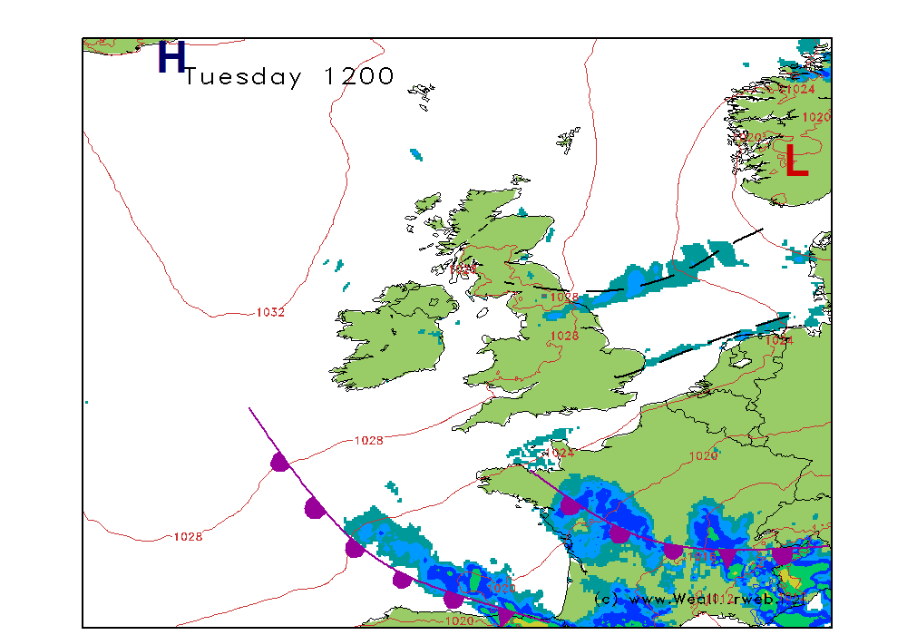
A slack pressure regime across the country on Saturday and for most western areas this signals a pleasant day. However, an occluded front is going to be dying away over northern Scotland, but at the same time a weak, waving front across southern England is likely to become rejuvenated, especially later in the day and may well introduce some thundery rain.
My thinking at the moment is that southern England probably starts the day fairly dull and cloudy, perhaps with a spot of rain, but essentially dry. Then, as the morning progresses some sunny spells come through and it feels warm. An area of more persistent rain then tracks into southwest England in the afternoon and this moves through southern England during the late afternoon and early evening. The rain could be heavy and thundery at times, but it will be rather hit and miss as to where it occurs. By the time it reaches southeast England and east Anglia it is likely to be fading away once again.
There will be some rain associated with the occlusion in the north, although this is going to be fading away too, and there is the risk of a few showers forming in the afternoon over northern England and the Midlands.
Most of Wales and Ireland should have a fair day with sunny spells.
Winds will be mainly S-SW 5-10 (F3) over England and Wales, ESE 7-12 (F3-F4) over Scotland.

SUNDAY:
Overnight I suspect a second area of thundery rain is going to be moving through southwest England, but this time it may move northwards into Wales and the Midlands as well as southern England and East Anglia, as the warm air associated with the warm front arrives. The weak occlusion over northern Scotland remains as an area of cloud and a few spots of rain on the hills.
The thundery rain in the south probably clears East Anglia early on Sunday afternoon, and then behind it will be more stable air as a ridge of high pressure builds. So, I suspect that for much of Wales, central and western England, Scotland and Ireland Sunday afternoon will probably be pleasant with some spells of sunshine. Always the threat of a thundery shower to the southeast and through East Anglia though.
Winds will be mainly N 10-12kt (F3-F4) over the east of England, NW 5-10 (F3) for Wales and western England, and an increasing E 14-18kt (F5) for Scotland.

***ends***
The Sailor's Book of the Weather by Simon Keeling is available now from http://eu.wiley.com/WileyCDA/WileyTitle ... 98032.html" onclick="window.open(this.href);return false;
Dr. Simon Keeling PhD, MSc (Appld. Meteorology & Climatology), FRMetS
Weather Consultancy Services
The Weather Centre, 188 Common Road, Wombourne,
Staffordshire, England. WV5 0LT.
Tel: (01902) 895252
http://www.weatherweb.net" onclick="window.open(this.href);return false;
http://www.weatherschool.co.uk" onclick="window.open(this.href);return false;
http://www.simonkeeling.co.uk" onclick="window.open(this.href);return false;

