


Wot No Wevver???
Moderator: weatherman


-
ash

- Yellow Admiral
- Posts: 1713
- Joined: Tue Mar 01, 2005 12:14 pm
- Boat Type: Moody 346
- Location: Tarbert, East Loch Tarbert, Loch Fyne, Scotland
Second Hand Weather
This the text from Simon's email service - Not sure if I can add the Gifs.
Edit - Yes I can
Ash
WEEKEND WEATHER FORECAST
Issued: 1000 Thursday 6th November 2008
SATURDAY:
Low pressure dominates the weather through Saturday, with the main centre to the northwest of Scotland. Fronts will be driving eastwards, the first being an occluded front which will clear the east of England through Saturday morning. An unstable southwesterly flow then follows, ahead of a further series of fronts crossing Ireland through the afternoon.
The occluded front brings rain to the east on Sunday morning, this then clearing and becoming drier for a time. However, a further area of showery rain moves through central and southern England. The second series of fronts then pushes rain through Ireland on Saturday morning, and into Wales and western England in the afternoon. Winds increasing significantly as this second area of rain arrives.
For Scotland rain in the east should fade, leaving it drier here, but for more western parts of the country a cloudy day seems likely with outbreaks of rain throughout and the hills staying shrouded in cloud.
Winds will be SW 12-16kt (F4-F5) behind the occluded front, increasing SW 25-30kt (F6-F7) as the rain arrives in the west later.

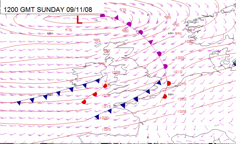
SUNDAY:
Low pressure remains to the north of Scotland through Sunday. A cold front clears the southeast in the morning, taking heavy rain with it. A further set of fronts then cross Ireland through the morning, and Wales and southern England in the afternoon. The winds remains strong to gale force everywhere.
A wet morning over much of central and southeast England with some heavy bursts of rain. This clears eastwards to be followed by a spell of drier weather.
Heavier rain moves through Ireland and then into Wales and southern England in the afternoon as the second set of fronts arrive.
For northern England and Scotland conditions will be cooler. Showers will be affecting western areas and these are going to be heavy at times. The showers turning increasingly wintry over the hills. More eastern parts of Scotland and northeast England will be brighter with only scattered showers.
Winds will be SW 20-30kt (F6-F7) reaching 35kt (F8) at times on the coasts of Wales, southwest England and Ireland.
The above has been extracted from the email which I received from Simon - I subscribe to his free email service.
Ash
Edit - Yes I can
Ash
WEEKEND WEATHER FORECAST
Issued: 1000 Thursday 6th November 2008
SATURDAY:
Low pressure dominates the weather through Saturday, with the main centre to the northwest of Scotland. Fronts will be driving eastwards, the first being an occluded front which will clear the east of England through Saturday morning. An unstable southwesterly flow then follows, ahead of a further series of fronts crossing Ireland through the afternoon.
The occluded front brings rain to the east on Sunday morning, this then clearing and becoming drier for a time. However, a further area of showery rain moves through central and southern England. The second series of fronts then pushes rain through Ireland on Saturday morning, and into Wales and western England in the afternoon. Winds increasing significantly as this second area of rain arrives.
For Scotland rain in the east should fade, leaving it drier here, but for more western parts of the country a cloudy day seems likely with outbreaks of rain throughout and the hills staying shrouded in cloud.
Winds will be SW 12-16kt (F4-F5) behind the occluded front, increasing SW 25-30kt (F6-F7) as the rain arrives in the west later.
SUNDAY:
Low pressure remains to the north of Scotland through Sunday. A cold front clears the southeast in the morning, taking heavy rain with it. A further set of fronts then cross Ireland through the morning, and Wales and southern England in the afternoon. The winds remains strong to gale force everywhere.
A wet morning over much of central and southeast England with some heavy bursts of rain. This clears eastwards to be followed by a spell of drier weather.
Heavier rain moves through Ireland and then into Wales and southern England in the afternoon as the second set of fronts arrive.
For northern England and Scotland conditions will be cooler. Showers will be affecting western areas and these are going to be heavy at times. The showers turning increasingly wintry over the hills. More eastern parts of Scotland and northeast England will be brighter with only scattered showers.
Winds will be SW 20-30kt (F6-F7) reaching 35kt (F8) at times on the coasts of Wales, southwest England and Ireland.
The above has been extracted from the email which I received from Simon - I subscribe to his free email service.
Ash
"This is a sailing Forum"
Albin Vega "Mistral" is now sold
Albin Vega "Mistral" is now sold