Clyde_Wanderer wrote:.
Thanks, S_S_O_L, we could probably meet up for a pint, if we are not pushing to do it in a day., C_W
The idea of a pint whilst attractive initself, was not the basis of the offer. Having done the transit a few times, the addition of a shore party with mountain bike to prepare the next lock and take shore lines ensures a speedy passage however, the Crinan can be frought with unexpected hazards such as drone ships. It is said that it is best to ensure that the helm has "been" should the skipper wish to disembark for a brief period.
The problem I have is mathmatical, I have the followwing equasion to contemplate:-
a+b+c+d+e=???
Mountain Bike = a
Canal tow path = b
succesful transit =c
pint = d
Clyde Wanderer and the inevitable poteen =e
That adds up nicely, and yes I hope to be carrying some of that special alternative fuel (=e) with me, especially intended for just those kind of occasions, even works on the bike.
Thanks again.
Cheers, C_W
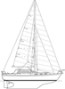
Nick wrote:.
Click the picture to go to Amazon to buy it.
The only publication to give anchoring / going ashore details for every island. Not a substitute for a pilot, but essential if you want to explore the lesser-known islands.
Thanks for that Nick, will order it up as soon.
Which pilot publication would you reccomend to accompany it?
Thanks also to you all for your replies.
C_W
Clyde_Wanderer wrote:
Which pilot publication would you reccomend to accompany it?
Thanks also to you all for your replies.
C_W
Some swear by the CCC sailing directions, Kintyre to Ardnamurchan is the one for that area. I'm a big fan of Martin Lawrence's 'Yachtsman's Pilot' series; the volume you need used to be called Crian to Canna but the current edition is called Waters Around Mull or somesuch. Ideally one would have both but at £25 a throw that's quite a lot of beer.
In addition to the Clyde Cruising Club (my first preference) and Martin Lawrence, you can easily download the freeNGA Sailing Directions, published by the US National Geospatial-Intelligence Agency. These SDs are very good.
You probably won't need the whole caboodle. so you can print off and laminate the pages you need. The The Mull of Kintyre to the Ross of Mull section is about 16 pages long. There is a lot of information in there and it includes some surprisingly small and out of the way anchorages.
Well Thanks again guys for your excellent help.
A couple of us are toying with the idea of maybe moving from crinnan to Ardfern or oban or even heading up Shuna sound to find an anchorage in around Seil or Torsa, (assuming that the Cuan sound is ok for passing through) before heading across to Mull.
I have now purchased the CCCpart 2 and ordered up SC5611 folio as I find these easy to use for chart work as the relevent sheets can be stacked or set in order of need, with the present one on one side and the next one on the other side of the envelope.
I am also going to purchase the Scottish Islands.
Thanks Markie, and Shard for the useful links.
Incidently how is Puilladobhrain for sheltered anchoring?
And last but not least, is there any good easy accessable pollack fishing around that area, ie some where with large beds of red kelp close to a safe anchorage?
Cheers, C_W.
Shuggy, Little Cumbrae might come on the market again, perhaps cheaper than the £3000000 it was up for before.
What about all us forumites getting together and buying it?
Another question or 20.
I think its called Balvicar bay? on the east side of seil, is there any anchorage there with reasonable depts for fin keelers?
To anchor there would save the further trip around to Puilladrobhain if intending to go for a pint or 20 in the T A T.
Unfortunatly the CCC guide doesent make any refference to Balvicar or the bay near it, although it does name it on the road atlas.
Cheers, C_W
Nick would know... I've picked up a visitor's buoy there but have never anchored. I don't think there's a lot of room round the moorings. You could be brave and go up the inside to the bridge, but it's pretty shallow. And you would need to go back down again the next day to get the Cuan. Sorry this is a short reply; I'm trying to see whether I've got £3 million in change in my piggy bank. If not, I'll have to raid the children's.
.
The bay is a bit congested for anchoring, but if it is reasonable weather you can anchor up at the top of Seil Sound just before it narrows into Clachan Sound in 6-8 metres. Exposed SE to SW, otherwise OK.
Not a criticism, but just an idle thought; what value would C-Map have coming into Puilladobhrain?
If you follow the transits on entry then you're probably no more than about 2 or 3m off the obvious rock on the port side; in such close quarters, surely the transits, plus a sharp lookout and exercising judgement would be better than using a GPS plotter?